 If the world were to ever overflow with lava, Microsoft Research would be first in the industry to have the maps for this new world. Last April, Danyel Fisher, a Microsoft Researcher at Redmond developed a tool to create a paradox of looking at what we look at on online maps.
He named his tool “Hotmaps” – Hotmail is reportedly upset – uses internal Microsoft statistics to generate a heatmap overlay for Virtual Earth. Areas of interest on the map with the most views (Bill’s house) are given bright red spots whilst areas without much interest with not many views are given dark spots (Steve’s house).
Previously used for only research purposes, now the tool is freely available for the public to see how many people are looking at their house and neighbors.
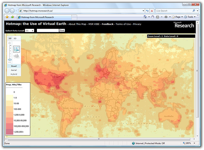
I’m surprised at just how many people look at the Pacific/Atlantic ocean. Is everyone looking for mermaids? I also wonder if we can create a tool to look at what we look at looking at what people look at on online maps. I’d call it, “Heatmaps for Hotmaps for Virtual Earth”.
Do you think Al Gore pushed for this? MS did all the live earth stuff, now hotmaps, sounds related to global warming.
To some degree, I think this reflects level of internet activity per nation, but I think it also reflects the countries to which Microsoft spends the most marketing its products.
I wonder how this would look if a huge corporation in China created the exact same service and marketed it there.
Looks like it popular where http://local.live.com/ has the best maps.
Although the popularity in Antarctica is suspicious!
Just “wish” Windows Live can increase their image coverage… especially Hong Kong =]
As the map above, we can see VE is quite popluar in Hong Kong!!!
*I live there and I believe if they creat it in a 3D version…
it will become one of the most visited place……
http://www.flickr.com/photos/root-2/219667953/
It’s interesting. People visit coordinates 0,0 too much!
Gotta say… it’s strange that this has been developed, but mildly interesting at the same time. A paradox between interesting and strange…
Good idea though… I think? *-)
Check out this tool that ripped your story verbatim!
http://www.windowsxlive.net/?p=1281
I have tried to install virtual 3D maps from the microsoft list of weekly updates. The installation took an incredibly long time and never confirmed that the installation was complete. I don’t know whether or not part of the program is installed or all of the program is installed. Nothing seems to work. How do I uninstall, please?
I only have a W2k computer. I accidently clipped on install button for “3D” at Map.live.com, and then quickly “aborted” the installation. Now I could not use map.live at all. What should I do now? Please help. Thank you very much.
“I’m surprised at just how many people look at the Pacific/Atlantic ocean. Is everyone looking for mermaids? ”
All mapping engines start centred on the US (on first use anyway), so I imagine that the reason the Atlantic is so popular is from Europeans scrolling the map to Europe!
Mapping websites should really get the approximate area that the user is in and just start from there, it would be so much faster. 🙂